Soil compaction is one of the most underestimated threats to long-term field productivity. When heavy machinery drives over the same paths – especially in wet or poorly drained conditions – it compresses the soil structure. This reduces pore space, limits water infiltration and air exchange, and restricts root growth. The damage isn’t always visible right away, but over time it leads to reduced yields, uneven crop development, and declining soil health. Preventing compaction requires more than just lighter equipment – it calls for smarter movement across the field.
We’ll explore how GPS fieldbee.com helps reduce soil compaction through better field navigation, controlled traffic patterns, and long-term field management strategies.
Controlled Traffic Farming (CTF)
GPS makes controlled traffic farming possible by guiding machinery along permanent, predefined tracks across the field. Instead of driving randomly or covering different areas each time, tractors and implements use the same wheel paths for multiple operations. This concentrates compaction in narrow zones while leaving the rest of the field undisturbed. Over time, this approach improves soil structure, boosts water retention, and leads to healthier root systems in uncompacted zones.
Repeatable Wheel Tracks
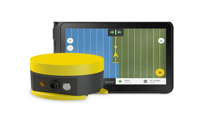
One of the key advantages of GPS is its ability to repeat the exact same driving paths season after season – with sub-inch precision when using RTK correction. This repeatability ensures that wheel traffic is consistently confined to designated tramlines, reducing random compaction across productive soil. It also simplifies planning and allows farms to align future operations with past patterns, supporting more consistent crop performance.
Avoiding Wet Zones
Driving through wet or waterlogged areas greatly increases the risk of deep and long-lasting soil compaction, which can take years to reverse. GPS systems – especially when integrated with field mapping and moisture data – help operators identify these sensitive zones before and during field operations. By planning field routes ahead of time or adjusting them on the go, farmers can avoid driving over saturated areas. This reduces the chance of rutting, maintains soil structure, and prevents costly remediation efforts later on. In wetter regions or during rainy seasons, this GPS-based awareness becomes a critical tool for soil preservation.
Optimized Headland Turns
Headlands – the turning areas at the ends of fields – often suffer the most from repeated traffic and tight maneuvers. GPS-assisted guidance enables smoother, more efficient turns that avoid overlapping previous wheel tracks. With tools like auto turn and headland management systems, operators can minimize the stress on soil in these zones, reduce repeated compaction, and ensure better overall soil condition throughout the field.
Long-Term Soil Mapping
GPS not only guides machinery but also record every movement across the field, building a precise history of traffic patterns over time. This data can be used to identify high-traffic areas, monitor how often specific zones are driven over, and evaluate the impact on soil structure and crop performance. By combining GPS records with yield maps or soil sampling data, farmers can make informed decisions about where to reduce traffic, where to subsoil, and how to rotate operations for better soil health. This helps turn compaction management into a strategic, data-driven part of farm planning.